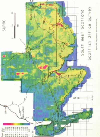
Sanderson Allyson, Tyler, Ni Riain and Murphy carried out an aerial survey to explore the presence of gamma-ray in parts of SW Scotland and to determine the potential of airborne radiometric techniques for swift response surveying of far-flung areas.1 The researchers were able to record about 17,000 gamma-ray spectra from major areas of Galloway and Dumfries and used them to map the dispersal of gamma-ray dose rate, 208TI, 214Bi, 40K, and 137Cs. The researchers documented and evaluated data during the research period and employed working calibration (from prior surveys) to transform data into absolute activity estimates. Consequently, they were able to generate some preliminary radiometric maps using a large set of gamma-ray spectra recorded during the fieldwork.2
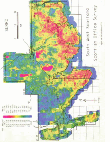
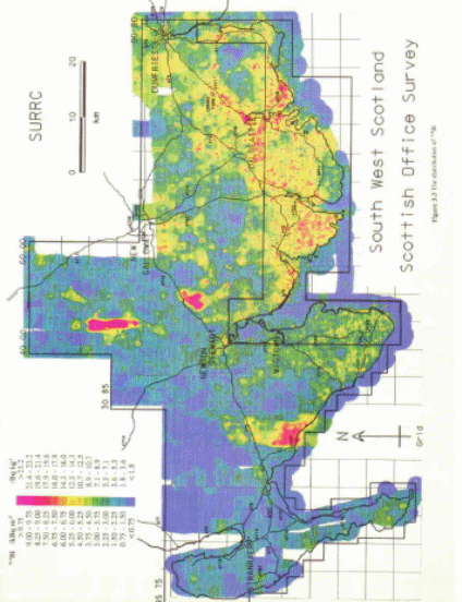
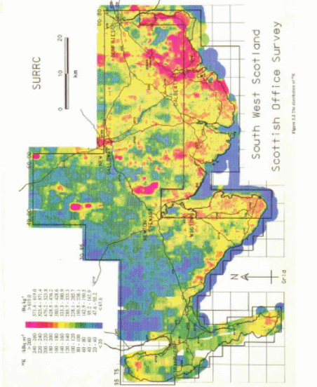
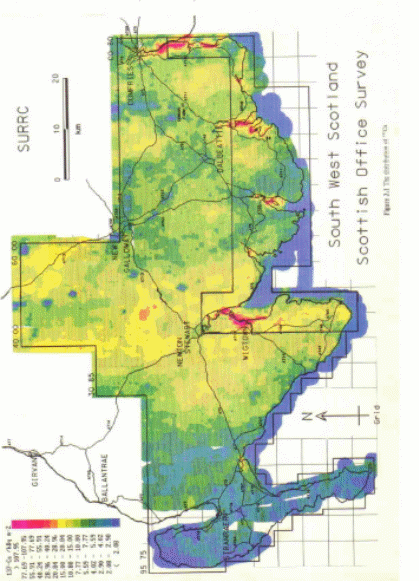
These maps3 reveal the overall distribution of 208TI, 214Bi, 40K, and 137Cs as well as the approximated ground level gamma-ray dosage rate. The maps also show the places and deposition layouts of Chernobyl fallout, dispersal of natural radioactivity, and regions where amplified series activity depicts potential radon enrichment. In addition, the maps reveal substantial degree of spatial variation of environmental radioactivity.4 According to the survey findings, the radiometric map for 137Cs shows that the radioactive discharge from Sellafield has accumulated within the marine ecosystem of salt mash areas. 5 Since the external gamma-ray dosage of salt marsh environments is subjugated by Sellafield-derived activity, these areas serve as environmental deposits for marine pollution and thus deserve further investigations. Given the prevalence of environmental radiation, the key area of focus is to assess critical group exposure, taking into consideration occupancy and deposited source characteristics, as well as to carry out time-series assessments to confirm whether radiation dosages are increasing or reducing within these critical areas.6
These maps also reveal the variability and quantities of Th, K, and U. 214BI signals and Granite incursions are evidently detectable. However, a correlation exists between 214BI and the dispersal of uranium-series activity (especially 226Ra), and latent radon sources of gamma-ray exposure to the human inhabitants. In addition, the correlation between quantities of radon in the soil and the natural dispersal of these sources is of utmost significance. Sanderson and associates concluded that the survey area exhibits substantial variations in uranium-series activity. Consequently, the researchers recommend further investigations to explore the impact of such variations on radiation exposure to human inhabitants.7 The gamma-ray dose rate map8 reveals that most radiation exposure is principally attributed to natural radioactivity. Nonetheless, external radiation (accruing from marine-related anthropogenic activity on salt marsh areas) regulates the local radiation dose rate.
An analysis of the gamma-ray dose rate map reveals that most environmental radiation exposures (which are deemed harmful to human inhabitants) are caused by natural sources. Nonetheless, it appears that external dosage rates, particularly on salt marsh areas, are largely regulated by the occurrence of 137Cs (resulting from marine ecosystems). The spatial range of salt marsh deposits is, nevertheless, higher compared to the findings of previous ground-based surveys.9 Large-scale radioactive pollution can justifiably result in substantial public panic. The Chernobyl incident exhibits the problems that might surface if a similar disaster were to recur. Nonetheless, considerable progress has been made since the Chernobyl disaster and it is anticipated that global treaties on the notification of accidents, permanent monitoring networks (i.e. RIMNET), and International Atomic Energy Agency (IAEA INES) system will be able to detect and deter the occurrence of a similar disaster in the future. In addition, Sanderson and associates suggest that more resources should be allocated to those areas that are most susceptible to radioactive exposure.10
A similar airborne gamma-ray survey was carried out by Allyson, Tyler, Ni Riain and Murphy within the precinct of the Springfields area and Ribble Estuary to explore the presence and levels of radiation elements.11 The survey outcomes were used to map the natural occurrence of gamma-ray flux, 137Cs ,208T1, 214Bi, and 40K. The findings of this study concur with prior conclusions that the concentration of 137Cs (within salt marshes) plays a major in external gamma-ray exposure. What’s more, the results of this study show that the contribution of Springfields to these sites is negligible compared to Sellafield-derived signal. In addition, this survey demonstrates clearly that those sites with137Cs deposits (where food chain effects and external gamma-ray exposure are of utmost concern) are found in the lower parts of the Ribble. On the other hand, the dispersal of 234mPa was prevalent in the upper areas of the river. From these findings, the researcher concluded that the distinctive exposure paths (i.e. skin dosage, external gamma-ray dosage) are not completely synergetic.12
In addition, the detection of potential natural sources of 228Ac within salt marsh ecosystem (as a result of the instability of the Th series soon after spring tides) is of utmost importance. If such occurrence is corroborated by further explorations, new knowledge will be generated regarding the active radiation settings of tide-washed ecosystems. The remarkable advancement concerning the use of aerial surveys to explore 234pa has been proven. Nonetheless, it seems that aerial survey is the only feasible technique for mapping dynamic sources. With regard to Ribble, it would be essential to decrease the aerial height of the survey to about 50metres (ground clearance) to enhance spatial resolution. Nevertheless, it would be prudent to take into account the potential disturbances of such low flights to inhabitants as well as the possible benefits of environmental information gleaned from the behaviors of these nuclides.13
Conclusion
It appears that the dosage rates presumed in prior airborne survey findings may have been underrated as a result of several factors such as geometric effects from modest sources, and the employment of calibration factor for converting dosage rates obtained from radiation fields. Although it has been proven that dosage rate estimates derived from airborne surveys of salt marshes of the Ribble are generally in harmony with periodical ground-based estimates, future surveys should explore the use of radiometric data to measure gamma-ray dose rates in survey areas.
Bibliography
Sanderson, DCW, JD, Allyson, AN, Tyler, S, Ni Riain & S, Murphy, An Airborne Gamma Ray Survey of Parts of SW Scotland in February 1993: Final Report, Scottish Universities Research and Reactor Centre, Glasgow, UK, 1997.
Sanderson, DCW, JD, Allyson, AN, Tyler, S, Ni Riain & S, Murphy, An Aerial Gamma Ray Survey of Springfields and the Ribble Estuary in September 1992: Technical Report, Scottish Universities Research and Reactor Centre, Glasgow, UK, 1992.
Appendix
Footnotes
- D Sanderson, JD Allyson, AN Tyler, S Ni Riain & S Murphy, An Airborne Gamma Ray Survey of Parts of SW Scotland in February 1993: Project Report, Scottish Universities Research and Reactor Centre, Glasgow, UK, 1997.
- Sanderson, p. 49.
- See Appendix.
- Sanderson, p.49.
- See Appendix, figure 4.
- Sanderson, p.51.
- Sanderson, p.52.
- See Appendix, figure 5.
- Sanderson, p.18.
- Sanderson, p.53.
- D Sanderson, JD Allyson, AN Tyler, S Ni Riain & S Murphy, An Aerial Gamma Ray Survey of Springfields and the Ribble Estuary in September 1992: Technical Report Scottish Universities Research and Reactor Centre, Glasgow, UK, 1992.
- Sanderson, Aerial Gamma Ray Survey, p.35.
- Sanderson, Aerial Gamma Ray Survey, p.35.
